


Last Thursday, March 3rd, saw a new eruption episode of the volcano Kilauea, located on the Big Island of Hawaii. The initial eruptions were prompted by earthquakes and resulted in the venting of dangerous sulfur dioxide gas, prompting Hawaiian officials to order evacuations of towns in the path of the eruption.
Though there was a day of relative calm on Saturday, this Sunday witnessed the Kilaeau vents begin violently erupting again, spewing lava as high as 200 feet into the air.
Eruptions And Evacuations
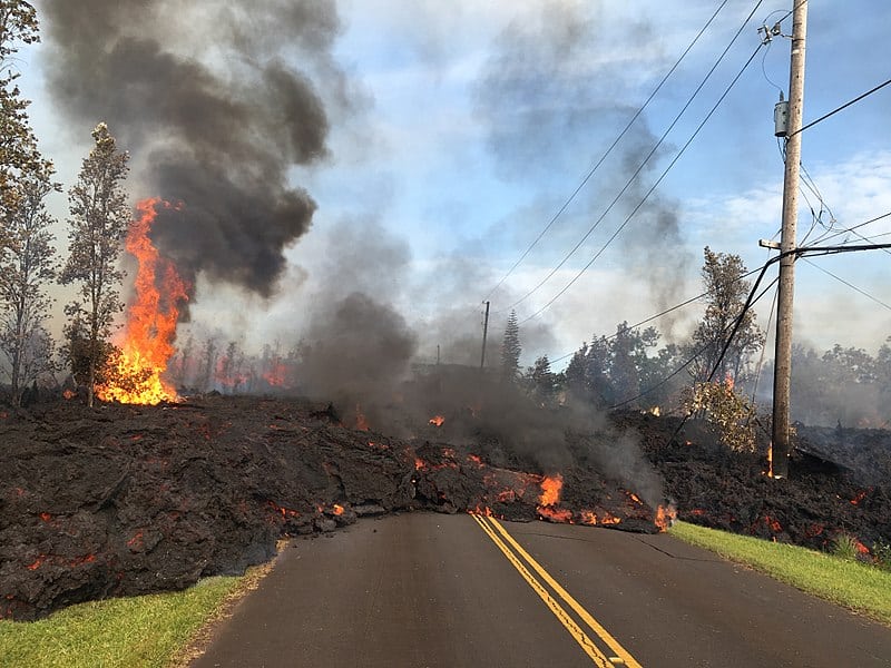
The volcanic activity that occurred Sunday forced open a new volcanic vent on the Big Island, meaning that there are now at least ten different vents that gas and lava can come spilling out of. Over 1800 residents of the neighborhoods near the vents, Leilani Estates and Lanipuna Gardens, have been evacuated and Hawaiian officials believe the problem is likely to get worse before it gets better.
Hawaii’s Civil Defense Administrator Talmadge Magno said that even though the vents seem to be relatively quiet for the moment, they expect the vents to violently come back to life soon.
More vents could open up, the existing ones could get active again, which probably will happen after seeing what happened this morning. There’s a lot of lava or magma under the ground so eventually, it’s going to come up.
The vents are being affected by a series of earthquakes which have besieged the island ever since Friday when a 6.9 magnitude earthquake struck. The quake was powerful enough to cause landslides on the island’s coast though little structural damage occurred. According to United States Geological Survey (USGS), the island was subject to over 500 earthquakes, thirteen of which had a magnitude greater than 4.0, in the day following the initial 6.9 magnitude quake. Most of the earthquakes were around magnitude 2.0.
Lava And Sulfur Dioxide
Yet while the earthquakes are distressing, the primary dangers caused by the volcano are the lava and volcanic gas emitted from volcanic vents. The earthquakes helped open fissures in the ground, some of which were as wide as 500 feet across. The lava is actively destroying people’s homes and the sulfur dioxide gas emitted by the vents is a toxic air pollutant which threatens people’s lungs.
Sulfur dioxide exposure causes the eyes, nose, and throat to burn and inflame, leading to difficulty breathing. Exposure to high levels of sulfur dioxide could even prove fatal to those who have pre-existing respiratory conditions.
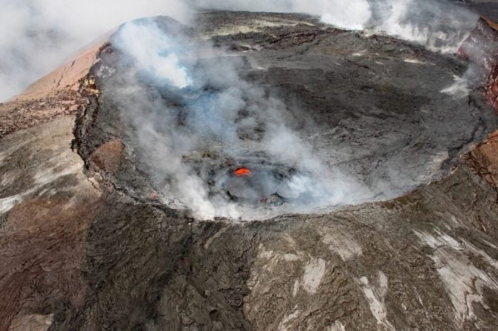
The crater at Kilauea. Photo: tommygbeatty via Pixabay, CC0
In areas that had been evacuated, but where sulfur dioxide levels were fairly low, residents were allowed to return home briefly to collect belongings on Sunday. Magno said that overall the levels of sulfur dioxide were still quite high and that residents wouldn’t be allowed to stay beyond getting belongings.
Thankfully there have been no reported fatalities connected with the eruption thanks to an eruption monitoring and alert system which has existed on the island for years. Though the Hawaiian Civil Defense organization says it’s difficult to correctly predict eruptions, they were aware that there was a high probability of an eruption and were able to warn the populace in advance.
Kilauea’s Constant Eruption
Kilauea is a shield volcano, and it’s the most active out of the five different volcanoes that together create the island of Hawaii. It’s a relatively young volcano that has a recently formed caldera at its summit. Shield volcanos are known for their traditionally gentle eruptions when compared with stratovolcanoes and cinder cone volcanoes. This had been true of Kilauea as well until recently.
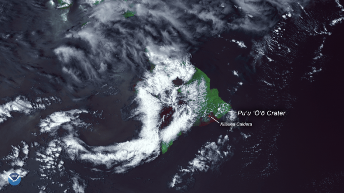
Photo: NOAA, Public Domain
Kilauea has been erupting almost nonstop since 1983, but these eruptions have traditionally been slow, calm and predictable making them relatively safe and a popular tourist destination. Almost all of the approximately two million yearly visitors the Big Island of Hawaii gets make a stop in the Hawaii Volcanoes National Park where Kilauea has been erupting. The 1983 eruption led to the creation of the Puʻu ʻŌʻō cone at the location of a vent along the eastern rift zone. The Puʻu ʻŌʻō cone continued to erupt over the years, making it the longest rift-zone eruption in the past two hundred years.
When the crater floor of the Puʻu ʻŌʻō vent collapsed, it may have kicked off the series of earthquakes which created the ground cracks and vents that would lead to the flowing lava and volcanic gas which have threatened citizens in the surrounding area.
Predicting Lava Flows
Civil defense officials and researchers have had difficulty predicting both the flow of lava and where a new fissure might open up. The lava flows that have been witnessed near the Leilani Estates are dubbed “a’a”, and they appear as slow, thick flows which are covered in cooling fragments. The lava on top cools and floats on top of the larger flow while the interior of the lava stays hot and liquid, driving forward. One of the reasons it’s difficult to predict the direction of a lava flow is because lava flows can have “breakouts” that drastically change the direction of flow. This happens because the front of a flow may cool and solidify, creating a barrier that backs up the lava until the pressure is sufficient enough for a breakout.
Scientists probabilistic models to try and guess where a fissure may open up the ground. They then create simulations that attempt to predict where lava would flow to if a fissure of a particular size were to open up at a particular spot and emit lava at a specific rate. The fact that there are so many variables involved with the models means that making these predictions is extremely challenging. Despite the challenges involved, creating prediction maps is necessary as it helps officials protect people from the dangers of eruptions.
Currently, the lava flows near Leilani haven’t moved very far from the fissures where they originated, so the prediction maps are fairly reliable right now. However, this could change drastically. During the 2014 lava flow event, lava flows from Puʻu ʻŌʻō advanced more than 20 miles towards the nearby town of Pahoa. USGS has to constantly update their maps as flows were diverted, breakouts formed, and topographical changes occurred.
It’s difficult to predict just how long the eruptions will continue for. According to geologists who’ve studied the seismic activities of the island, the seismic activities closely mirror a 1955 eruption that went on for almost three months and covered approximately 4,000 acres of land in lava. Meanwhile, flow from the ongoing eruption of Kilauea began threatening the town of Pahoa in late June of 2014 and didn’t let up until March of 2015.
Yet while the lava continues to flow from fissures near Kilaueau, scientists will continue to study how lava flows and changes in an effort to understand the changing landscape and to better protect people from eruptions in the future.
Related Posts
 Duck-Billed Dinosaurs Uncovered In Aniakchak, Alaska
 Cryptic Diversity In Vietnam’s Limestone Karst Habitats
 An Improved Method To Remove Debris From Cyst Nematode Egg Suspensions And Computer-Aided Technologies For Egg Counting
 The Footprints Of Urbanization, Industrialization, And Agriculture On River Beds: Heavy Metal Contamination Assessment And Source Identification In River Sediments In Eastern China
 Aging Dolphins Via Pectoral Flipper Radiography
 Glycoalkaloids In Potatoes: The Effect Of Biostimulants And Herbicides