The international scientific community has been studying climate change and increases in the atmospheric concentrations of carbon dioxide (CO2) for decades. Receiving less attention is methane (CH4), which is emitted at much lower rates than CO2, but yet it is 25 times more potent than CO2 for trapping heat in the atmosphere.
Considering emission rates and potency, CH4 is the second most important contributor to the enhanced greenhouse effect. The latest remote sensing technology, deployed into space in October 2017, gives us the capabilities for estimating concentrations of numerous atmospheric gases (e.g., CH4 concentrations) at high temporal- and spatial- resolutions. With these open-access data, scientists will be able to reduce uncertainties in atmospheric variables and develop more useful atmospheric and climatic models. Let us explore some background on concentrations, emissions, and our improved capacity for monitoring and modeling CH4 in the atmosphere.
Methanogenesis or biomethanation is a natural process whereby microbes, known as methanogens, produce methane. Several natural processes generate (i.e., emit) CH4 including anaerobic decomposition of organic matter, enteric fermentation in animals, and the decomposition of animal wastes. However, atmospheric concentrations of CH4 have increased from a pre-industrial (~1750) value of about 700 ppb to an estimated 1,834 ppb in 2015, which is a strong indicator that human activity effects CH4 concentrations in the atmosphere.
The Intergovernmental Panel on Climate Change (IPCC) reports that slightly more than half of the current CH4 flux to the atmosphere is anthropogenic with methanogenesis occurring in agricultural activities, wastewater treatment, landfills, some industrial processes, and land use, land-use change & forestry (LULUCF). Anthropogenic CH4 emissions are also associated with petroleum operations, coal mining, and incomplete combustion. Due to the CH4 emission rate increases at 5 ppb/year, it is important to continually improve trend monitoring to verify that policies, such as those under the IPCC, are effective for controlling and reducing emissions to the atmosphere.
Bottom-up and Top-down Methods for Estimating Methane Emissions:
Atmospheric concentrations are estimated in units of CO2-equivalent by “bottom-up” methods that compute methane emissions as the product of activity rate (e.g., number of gas wells drilled) and emission factors per unit of activity (e.g., methane emission per well drilled). “Top-down” assessments use atmospheric measures to quantify emissions. Remote sensors (e.g., measurements from satellites) are used for global coverage, while high-frequency measurements of greenhouse gases at ground and high-altitude stations are combined to “ground-truth” top-down modeling of large-scale greenhouse gas emissions.
Satellite-based sensors, such as the European Scanning Imaging Absorption Spectrometer for Atmospheric Chartography (SCIAMACHY) instrument and Japan’s Greenhouse Gases Observing Satellite (GOSAT), have been used to measure reflected solar energy and map large-scale atmospheric concentrations of carbon-containing gases.
TROPOMI:
The TROPOspheric Monitoring Instrument (TROPOMI) uses a spectrometer to record direct and reflected (by the Earth) solar energy at different wavelengths including ultraviolet, visible, near infrared, and short-wavelength infrared. A comparison of direct versus reflected reveals which gases are present in our atmosphere and in what quantities. TROPOMI uses high-quality mirrors to produce accurate high-resolution images for air quality around the entire Earth.
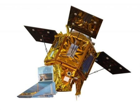
 Rendering of the Sentinel-5 Precursor (55p) satellite with the TROPOMI payload, where TROPOMI will detect ozone, methane, formaldehyde, aerosol, carbon monoxide, nitrogen dioxide, and sulfur dioxide. Photo By SkywalkerPL from https://commons.wikimedia.org/wiki/Main_Page
TROPOMI was launched in October 2017 and is on board the Copernicus Sentinel-5 Precursor (S5p) satellite, which is the first of the atmospheric composition Sentinels. For about a month after the launch, TROPOMI was undergoing an “annealing” process, whereby water vapor and volatiles released during the launch were removed using heating elements. Presumably, the S5p and TROPOMI are now orbiting at a distance of about 800 kilometers from the Earth.
The satellite will experience temperatures ranging from about -130 degrees Celsius to +130 degrees Celsius. Some of the detectors that record images are expected to deteriorate and pixels might stop functioning over time, but the anticipated lifespan is seven years. Over its operational life, TROPOMI will observe daily global CH4 column concentrations at a high spatial resolution on the order of a couple of city blocks (7 km by 7 km), and sufficient accuracy to facilitate inverse modeling of sources and sinks. Data from the ground-based Total Carbon Column Observing Network (TCCON) will be used for verification and validation of TROPOMI.
Sensors on TROPOMI are solid, reliable, and lightweight with an immersed grating (light reflected by earth’s atmosphere with direct sunlight by using mirrors) and freeform optics as key innovations. These technologies, engineered by the Netherlands Institute for Space Research, were downsized forty times compared to their predecessors while enhancing precision and image quality. Data gathered by TROPOMI will be made available to scientific and educational data user communities throughout the world via the Copernicus Open Access Hub.


