A sense of place can be broadly defined as the collection of meanings, values, symbols, and feelings people associate with a particular locality1, and it is a concept that is widely recognized by scholars and researchers as being integral for sustainable natural resource planning and management. By understanding and giving due attention to people’s relationships to a place, a natural area can be managed in a manner that is socially and culturally conscious, as well as environmentally and economically sound.
Although recognized as important, effectively incorporating people-place relationships into planning and management can be a challenging task. These relationships are complex and based on a wide variety of social and environmental factors. This, in turn, makes it very difficult to understand and characterize the sense of place of the various people affected by a resource management plan or strategy. Also, “places” are unlike “spaces” in that they have fuzzy, difficult-to-define boundaries, which create difficulties and confusion around determining exactly where certain place-based values are associated.
These challenges bring to light a need for tools that can capture place characteristics and can communicate to stakeholders whether a proposed strategy or plan might align or conflict with their sense of place. Such tools need to go beyond primarily spatial representations of areas and environments (e.g., simple maps). Instead, as we previously argued2,3, such challenges present a role for realistic, geographically-accurate representations of real-world environments.
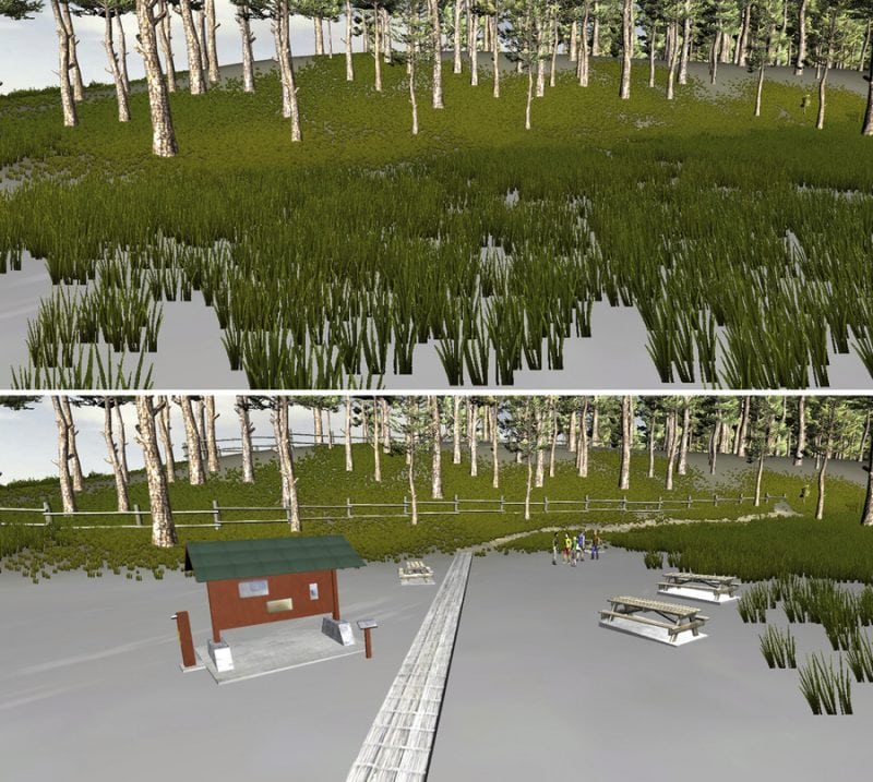
These tools, which we refer to as “geovisualizations,” can give people vivid impressions of how they would feel about certain management outcomes or impacts if they actually occurred in real places. Other studies4,5 have found that visualization tools can elicit strong emotional reactions from users when seeing dramatic changes to familiar places. Such reactions indicate that the visual representations are connecting with people’s sense of place, thus demonstrating potential as tools for understanding and incorporating people-place relationships into resource planning.

Figure 1. Example of a realistic geovisualization depicting potential changes to a place. Taken from Newell and Canessa, 2018
Place-based applications of geovisualization tools appear promising and could greatly support efforts toward making resource management more socially and culturally sensitive. However, despite this promise, geovisualization and sense of place research are very rarely explicitly linked and explored in the same studies. Recognizing this research gap, we conducted a study that firstly, identified relationships between people’s sense of place and the way they visualize places, and secondly, considered what these relationships could tell us about how to develop and use geovisualizations.
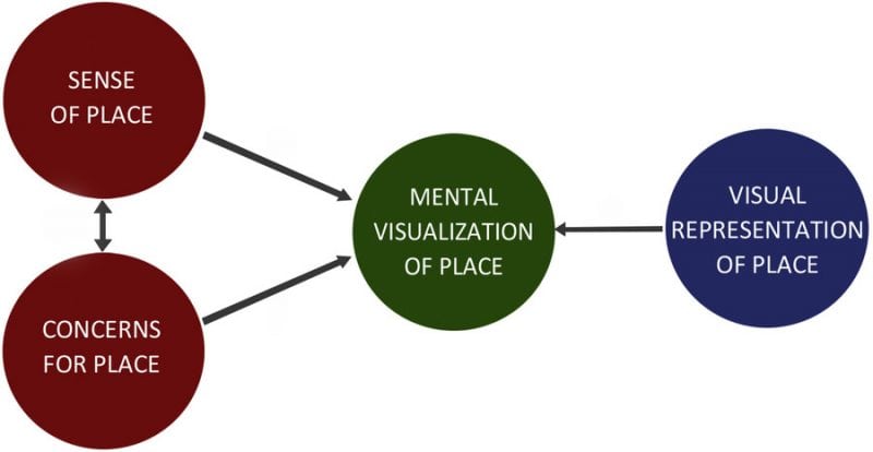
Using the Greater Victoria Area (BC, Canada) as a study site, we approached this research by looking at how different aspects of the sense of place relate to how people “mentally picture” places, particularly coastal places. In turn, this allowed us to think about how geovisualizations (and planning scenarios are shown within these visualizations) might align or conflict with these mental images. In addition, we also explored concerns for coastal places, thinking that this could be an interesting proxy for exploring how a sense of place relates to mental visualizations of place.

Figure 2. Approach for examining the relationship between sense of place and visualization of place. Taken from Newell and Canessa, 2018
In an effort to bridge place theory and geovisualization research, we drew on methods that environmental psychologists and human geographers use to study sense of place and place attachment, and we combined these with mental visualization techniques adapted from work conducted by virtual environment researchers6. We mailed out a survey to residents of the Greater Victoria Area, and survey questions asked participants about their values, beliefs, and feelings for local coastal places (i.e., sense of place), as well as their concerns for these places. In addition, we asked participants to close their eyes, picture a local coastal place, and write down some of the things they “see” in this picture. When asking participants to picture these places, we also requested that they note where they were positioned in their picture and what direction they were facing.
As often done in environmental psychology and human geography studies, we first identified different aspects or “dimensions” of sense of place. Included in these dimensions were place identity and place dependence. Place identity refers to people’s attachment to places based on attitudes, beliefs, and feelings, and place dependence is attachment based on activities performed in the place, such as how suitable it is for certain types of recreation. Two other sense of place dimensions were found through our data, and these centered on values for nature protection and values for the community and economic well-being.
We also identified four dimensions for coastal concerns. These dimensions were associated with the health of the local ecosystem, private property rights and opportunities, public rights and access, and impacts from boats.
After identifying sense of place and concerns dimension, we ran regressions to see if (and how) sense of place and concerns for place relate to how people mentally picture these places. We found statistical evidence for these relationships, and some of these were expected or intuitive, indicating that our novel methodology was producing results that “made sense.” For example, nature protection values and ecological concerns both increased chances of people including wildlife elements in their mental picture of local coastal places.
Other relationships were more nuanced, and these findings held implications for the development of coastal geovisualizations. For example, place identity led to mental pictures that specifically included marine wildlife. Accordingly, coastal geovisualization developers should recognize the particular significance of modeling marine life elements when collaborating with stakeholders of high place identity, especially when displaying planning scenarios that could affect these species.
In addition to relating to what was included in a mental picture, we also found that different place relationships resulted in people seeing their mental picture from different perspectives. For example, place dependence increased chances of people visualizing coastal places from the perspective of being on a boat. Such findings make sense, as place dependence refers to attachments to places that formed through the activities performed there; however, the findings also tell us that geovisualizations should be equipped with the ability to experience them from multiple perspectives in order to adequately speak to people with different place relationships. Coastal users with particularly strong place dependence might “imagine” coastal places from the perspective of being on a boat, and thus coastal geovisualizations should include options to examine planning scenarios from the boaters’ perspective.
Interestingly, about a fifth of the participants identified non-visual elements in their mental images of coastal places, such as sounds, smells, and temperatures. This was unexpected because we used very visually-oriented terminology in the survey instructions, specifically asking people to identify what they “visualize” in their “mental pictures.” Such findings reflect how relationships with place are formed and influenced through a wide range of senses. Accordingly, researchers and practitioners should consider developing geovisualizations that engage multiple senses in order to enhance their potential to serve as place-based tools. Indeed, we have done this in our applied research and experimented with coastal geovisualizations that include audio components7,8. Our hope is that other researchers will build on this work, and continually explore how to develop and use better tools for sustainably managing the precious places of our world.
These findings are described in the article entitled From sense of place to visualization of place: Examining people-place relationships for insight on developing geovisualizations, recently published in the journal Heliyon. This work was conducted by Robert Newell and Rosaline Canessa from the University of Victoria.
References:
- Williams, D., & Stewart, S. (1998). Sense of place: An elusive concept that is finding a home in ecosystem management. Journal of Forestry 96(5), 18-23.
- Newell, R., & Canessa, R. (2015). Seeing, believing, and feeling: The relationship between sense of place and geovisualization research. Spaces and Flows: An International Journal of Urban and ExtraUrban Studies 6(4), 15-30. doi: 10.18848/2154-8676/CGP/v06i04/53779
- Newell, R., & Canessa, R. (2017). Picturing a place by the sea: Geovisualizations as place-based tools for collaborative coastal management. Ocean & Coastal Management 141, 29-42. doi: 10.1016/j.ocecoaman.2017.03.002
- Newell, R., & Canessa, R. (2018). From sense of place to visualization of place: examining people-place relationships for insight on developing geovisualizations. Heliyon, 4(2), e00547.https://doi.org/10.1016/j.heliyon.2018.e00547
- Salter, J. D., Campbell, C., Journeay, M., & Sheppard, S. R. J. (2009). The digital workshop: exploring the use of interactive and immersive visualisation tools in participatory planning. Journal of Environmental Management 90, 2090-2101. doi: 10.1016/j.jenvman.2007.08.023
- Schroth, O., Hayek, U. W., Lange, E., Sheppard, S. R. J., & Schmid, W. A. (2011). Multiple-case study of landscape visualizations as a tool in transdisciplinary planning workshops. Landscape Journal 30(1), 53-71. doi: 10.3368/lj.30.1.53
- Turner, S., Turner, P., Caroll, F., O’Neill, S., Benyon, D., McCall, R., & Smyth, M. (2003). Re-creating the botanics: Towards a sense of place in virtual environments. In Third UK Environmental Psychology Conference. Aberdeen, UK.
- Newell, R., Canessa, R., & Sharma, T. (2017). Modelling both the space and place of coastal environments: Exploring an approach for developing realistic geovisualizations of coastal places. Frontiers in Marine Science 4, 87. doi: 10.3389/fmars.2017.00087
- Newell, R., Canessa, R., & Sharma, T. (2017). Visualizing our options for coastal places: Exploring realistic immersive geovisualizations as tools for inclusive approaches to coastal planning and management. Frontiers in Marine Science 4, 290 https://doi.org/10.3389/fmars.2017.00290


