


On May 12th, 2008, an earthquake of magnitude 7.9 (Mw) hit the Longmen mountain range in the west part of Sichuan, in China. The seismic rupture propagated along the fault for more than 240 km and displaced and raised the land surface, in some points, by up to 10 meters. The earthquake lasted two interminable minutes. It killed almost 90,000 people, injured more than 450,000, and destroyed the dwellings of almost five million people, who had to be relocated in temporary shelters. Overall, the earthquake caused about $150 billion US dollars of direct damage.
In addition to the immediate impact on the population, the Wenchuan Earthquake was the recent earthquake that caused the largest chain effects on the landscape. The seismic shaking caused nearly 200,000 landslides, whose sizes ranged from small shallow slides to enormous rock avalanches. One of them, the Daguangbao mega slide, practically cut a mountain on half. With more than one billion cubic meters of displaced material, it was the largest earthquake-induced landslide ever documented.
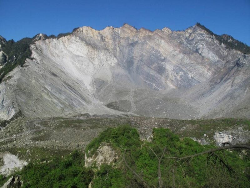
The largest earthquake-induced landslide (the Daguangbao mega-slide, > 1 billion cubic meters). Credit: SKLGP
Several landslides reached the deeply-incised mountain valleys, damming their water streams and forming over 800 lakes. In many cases, the impounded water breached these dams, weeks or months later, emptying the lakes at once. The impressive water discharge flooded the valleys for tens to hundreds of kilometers, making more victims and further desolation.
Many other landslides never reached the valleys. They stopped their run along the mountain slopes, forming numerous and widespread deposits of crushed rock, large boulders, and fine soil. An impressive quantity, actually: it has been calculated that all this debris has a volume of 5-15 cubic kilometers. Its texture and structure, unconsolidated and highly porous, makes it highly hazardous and prone to collapsing if disturbed. This is what actually happened during the monsoon seasons in the years following the earthquake. The heavy rains wetted, saturated, eroded and destabilized many of the deposits. The mixtures of debris and water, behaving pretty much like a liquid rather than a solid (we call this process “fluidization”), reached impressive speeds (100-150 km/h and more!) while flowing downslope, and had enough energy to eradicate trees, scrape the surface for several meters and, of course, destroy buildings, roads and everything else they encountered. One of the most catastrophic events happened during the summer of 2010 in Yingxiu, a town very close to the earthquake’s epicenter, where a large debris flow completely submerged the newly reconstructed quarters.
Ten years after the earthquake, although the frequency of these catastrophic events is decreasing and the landscape response to rainfall seems normalizing, we find that most of the earthquake-generated debris is still along the slopes, possibly ready to produce new landslides under (un)favorable conditions. Moreover, the seismic shaking certainly weakened, cracked and fractured many rock slopes and ridges. This enhances their mechanical degradation so that, even though they did not collapse during the earthquake or soon afterward, many rock masses can fail and generate destructive landslides even many decades later. This happened last year, for example, in another region of Sichuan, where an avalanche of several million cubic meters of rock destroyed an entire village, 84 years after the strong earthquake that cracked the mountain ridge where the landslide originated.
The chains of natural hazards induced by the Wenchuan earthquake acted as a strong motivation for researchers worldwide to investigate each ring of this chain and how they are connected. Studies have been (and are being) made on how earthquake-induced landslides occur, where they are most likely to happen and why, where the material deposits, how any why it is remobilized by the heavy rainfalls, how the debris flows are generated, how landslides dam rivers and how the rivers breach them, and, ultimately, how long the effect of a strong earthquake on the mountainous landscape lasts. Since the Wenchuan earthquake, more than 6,000 scientific articles — authored by researchers from 67 countries — were published, more than 1,000 of which targeted exactly one of the above issues.
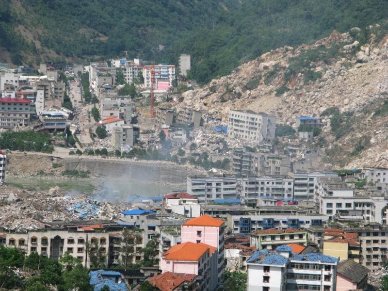
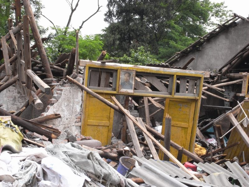
View of Beichuan, one of the many towns destroyed by the concurrent action of the seismic shaking and the landslides coming from the steep slopes. Beichuan was built exactly over the fault. Here, one landslide buried a middle school, making more than 700 victims alone, and another hit the old town killing more than 1,600. Credit: SKLGP
For the 10th anniversary of the 2008 Wenchuan Earthquake, a first review of the recent advances in our understanding of the earthquake-induced chains of geohazards has been published in the journal Engineering Geology. The work is co-authored by Xuanmei Fan, Runqiu Huang, Qiang Xu and Gianvito Scaringi (State Key Laboratory of Geohazard Prevention and Geoenvironment Protection, Chengdu, Sichuan, China), Hsein Juang (Clemson University, USA), Janusz Wasowski (National Research Council of Italy), Cees van Westen (University of Twente, Netherlands) and Hans-Balder Havenith (Université de Liège, Belgium).
To mark this anniversary, and in memory of the many victims, the State Key Laboratory of Geohazard Prevention and Geoenvironment Protection is also hosting the 5th International Symposium on Mega Earthquake Induced Geo-disasters and Long-Term Effects (MEGE 2018, www.mege.net) from May 11th to 16th. It will be the venue for the worldwide scientific community to share the most recent advancements and discuss the challenges in the understanding of the earthquake-induced geohazard and in controlling and mitigating the risks for the population.
Related Posts
 Duck-Billed Dinosaurs Uncovered In Aniakchak, Alaska
 Cryptic Diversity In Vietnam’s Limestone Karst Habitats
 An Improved Method To Remove Debris From Cyst Nematode Egg Suspensions And Computer-Aided Technologies For Egg Counting
 The Footprints Of Urbanization, Industrialization, And Agriculture On River Beds: Heavy Metal Contamination Assessment And Source Identification In River Sediments In Eastern China
 Aging Dolphins Via Pectoral Flipper Radiography
 Glycoalkaloids In Potatoes: The Effect Of Biostimulants And Herbicides