


Asia’s summer monsoon rainfall is a lifeline for more than two billion people. The long-term average rainfall extremes vary on a year-to-year basis. It is manifested in the form of large-scale floods and droughts, which cause devastating human and economic losses.
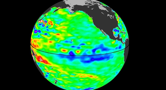
Changes in summer monsoon rainfall are closely linked to variations in the Pacific Climate. The most significant and well-known cause of inter-annual variability in the tropical Pacific is the El Niño Southern Oscillation (ENSO). ENSO characterizes the interannual fluctuations in the tropical Pacific Ocean sea surface temperature (SST). This SST variation has important implications on the weather and climate over several parts of the globe, including the South and East Asian regions. The positive or warmer (versus negative or colder) SST deviations from climatological values for a pre-assigned location along the equator on the central Pacific Ocean are named El Niño (La Niña) events. The time period from an El Niño to a La Niña to the next El Niño ranges between 2-7 years, peaking usually during the northern hemisphere’s winter.
By far, El Niño’s influence on the Asian region’s summer rainfall variability is thought to be a critical component. In general, El Niño events tend to decay rapidly by the following summer, but La Niña events can persist throughout the year and re-intensify during the subsequent winter, thus occurring as multiple-year events.
Studies show that the cold SST anomalies associated with La Niña over the eastern equatorial Pacific Ocean favor an above-normal monsoon rainfall over the South Asian region and below normal rainfall over the East Asian region. Singh et al. (2013) found that long-lived La Niña events cause anomalous SST cooling over the tropical southwest Indian Ocean through atmospheric teleconnections and reduces the local convection. However, it is not known how multiyear La Niña events affect South and East Asian summer monsoons by means of atmospheric teleconnections. This article speaks about the effects of such multi-year La Niña events.
The multiple year La Niña events: SST patterns
Our study suggests that the cooler SST anomalies of the following year are slightly shifted toward the south and south-central Pacific Ocean compared to the preceding year (Fig. 1). This shift affects atmospheric circulation patterns around the world, the columnar moisture content, as well as temperature and rainfall distributions. We have examined 2 consecutive summer teleconnections after the first peak phase in a La Niña event. Disregarding the peak during winter, the analysis was carried out for the following summers, referred to as the first and second years. An Atlantic Niño-like pattern, which can be termed as El Niño’s cousin in the Atlantic Ocean, was evident in the first year summer, but not in the second. This Atlantic Niño had contributed to the persistence of a strong La Niña in the Pacific during the subsequent winter.
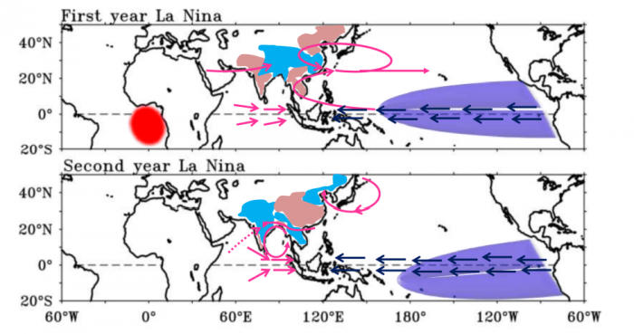
Figure 1. Schematic diagram that shows summer rainfall, circulation and SST patterns over South Asia, East Asia and Pacific region during Multi-Year La Niña events. Lavender colour show SST cooling associated with La Niña and red colour over Atlantic indicate SST warming related to Atlantic Niño. Blue and brown shading over South and East Asian region indicates positive and negative rainfall pattern respectively. Different coloured thick (dashed) arrows and curves indicate strong (weak) 850 hPa wind anomalies. Figure courtesy Jasti Chowdary.
Teleconnections to South and East Asia summer rainfall
During the first year, negative rainfall anomalies are found over most of the South Asian countries except Bangladesh and Sundarbans, and vice-versa for the second year. Meanwhile, a tri-pole like structure in rainfall anomalies was reported in the East Asian Monsoon region with positive rainfall over southern and central China and negative over parts flanking the north and south of this region (Myanmar, Thailand, and Cambodia regions and north-east China-North Korea) during the first year, and vice-versa during the second year. This reveals that the multiyear La Niña events have a diversifying impact on the summer monsoon rainfall over South and East Asia.
Analysis of observations reveals a distinct evolution of atmospheric teleconnections to the South and East Asian precipitation anomalies during multiyear La Niña events. In the first year, moisture convergence supported by low-level circulation to the north of Bangladesh and central India results in positive rainfall anomalies over those regions. The negative Vertically Integrated Moisture (VIM) anomalies (the columnar moisture content) over the rest of the subcontinent are closely related to negative rainfall anomalies. In the case of the second year, anomalous low-level anti-clockwise type (cyclonic) circulation over the central Bay of Bengal enhanced the moisture transport into the Indian subcontinent and, hence, resulted in positive rainfall anomalies.
In the East Asian region, the second year’s tri-pole like structure in the VIM supported the similar rainfall anomalies. The same was not true during the first year; however, anomalous negative VIM over Cambodia and Thailand were consistent with negative rainfall anomalies during the same time.
In addition to these changes, the Atlantic Niño had also been found to be remotely influencing South Asian rainfall during the first year (e.g., Yadav et al. 2019). The SST warming associated with the Atlantic Niño intensified the Inter-Tropical Convergence Zone (ITCZ). The ITCZ is the east-west strip of maximum rainfall over the tropical regions, where the trade winds from the northern and southern hemispheres meet.
This further enhanced the upper-tropospheric divergence over the eastern equatorial Atlantic and West Africa, which can be thought of as spreading of hot air on the inner side of a kettle’s lid. As a result, large-scale circulation adjustments and wave activities weaken the west-to-east-flowing jet in the midlatitudes. It also contributes to the below-normal rainfall over the northwestern parts of India and to the above-normal rainfall over the south-east Tibetan Plateau and Bangladesh regions. The World Climate Research Programme (WCRP) Coupled Model Intercomparison Project Phase 5 (CMIP5) models showed limited skills in representing these teleconnections.
Related Posts
 Duck-Billed Dinosaurs Uncovered In Aniakchak, Alaska
 Cryptic Diversity In Vietnam’s Limestone Karst Habitats
 An Improved Method To Remove Debris From Cyst Nematode Egg Suspensions And Computer-Aided Technologies For Egg Counting
 The Footprints Of Urbanization, Industrialization, And Agriculture On River Beds: Heavy Metal Contamination Assessment And Source Identification In River Sediments In Eastern China
 Aging Dolphins Via Pectoral Flipper Radiography
 Glycoalkaloids In Potatoes: The Effect Of Biostimulants And Herbicides