The pre-Hispanic city of Mexico-Tenochtitlan, capital of the Mexica Empire, was built between the years 1300 and 1521 A.D. in the place where now stands the populated metropolis of Mexico City. After the Spanish colonization, all the former Mexica buildings were demolished and a new urban design was drawn.
The remaining materials were reused for the construction of the new colonial edifices and, in some areas, the original layout was preserved. The modern urban development has allowed the recovery of several archaeological structures through archaeological salvage projects, which provided a wider understanding of this ancient culture. Nevertheless, most of the knowledge is still buried underground. For example, the exact position of the north-western corner of the great wall that enclosed the ceremonial precinct of Tenochtitlan remained as an unknown yet undeciphered.
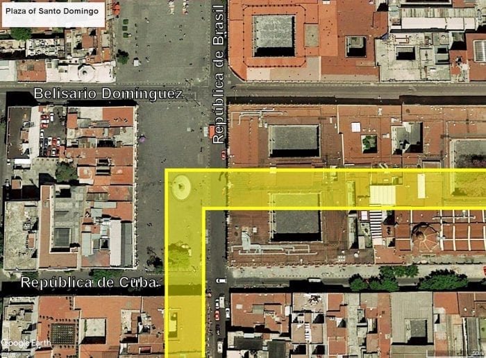
In 2013, the Mexican archeologists Álvaro Barrera Rivera and Alicia Islas Domínguez published a general study of the main area of this pre-Hispanic city (“Arqueología urbana en la reconstrucción arquitectónica del Recinto Sagrado de México-Tenochtitlan”). In their study, the authors proposed a possible location for the NW corner of the aforementioned surrounding wall by computing the distance between the center of the eastern wall (exposed in the platform of the Templo Mayor) and the southeast corner (discovered through archaeological excavations under the Marian court of the National Palace), and projecting the same distance towards the north. Based on this projection, Barrera and Islas proposed that the northwest corner could be located practically in the middle of the Plaza of Santo Domingo.

Projection of the wall that enclosed the ceremonial precinct of Mexico-Tenochtitlan. Credit: Google Earth
The Plaza of Santo Domingo is situated within the historical center of Mexico City, three streets to the north of the main square and the Metropolitan Cathedral. This public square has never been studied with archaeological excavations; therefore, the only information we had regarding the origin and history of its transformations originates from other sources and disciplines. In order to corroborate the exact position of the northwest corner of the ancient Mexica wall, without performing archaeological excavations in such a conflictive urban area, a 2D Electrical Resistivity Tomography (2D -ERT) study was carried out.
Using ERT To Examine Archaeological Sites
ERT is a geophysical method that injects an electrical current into the subsoil through a couple of electrodes and measures the response of the materials to this field with another pair of electrodes. This method allows the characterization of lateral and vertical variations of the electrical properties produced by buried materials without destroying or altering the context, determining the spatial distribution of the buried features and providing answers to questions of archaeological significance. The resulting electrical images display the constructive scene enclosed in the subsoil of a site in terms of their resistivity contrasts, allowing us to detect different types of targets of natural or human origin.
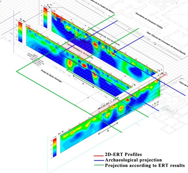
In order to achieve the goal of this study, we implemented three 80-m-long ERT profiles in the plaza: two parallel profiles in the middle of the plaza running from south to north along the major axis of the public square and one running from east to west along the southern side of the plaza. For each profile, a Wenner-Schlumberger array with 81 electrodes and a separation of 1 m between electrodes was designed for the survey. The equipment employed was a SyscalPro48 with a switch box that allowed the installation of 48 additional electrodes. Profiles 1 and 2 had the purpose of determining the location of the north section of the wall, while profile 3 was intended to locate its west section. By acquiring this information, we could be able to project the position of the north-western corner.
The observations in the electric profiles beneath the plaza identified an anomaly with similar characteristics (size, geometry, and position) in all cases, revealing the presence of a pre-Hispanic structure that could be part of the wall that surrounded the Mexica ceremonial compound. This anomaly was characterized by a low-resistivity structure (16 m width and at a depth below 5 m) with well-defined vertical edges detected towards the center of the profiles; this central element seems to represent the core of the wall, composed of dirt and tezontle blocks (a porous volcanic rock) and, therefore, more heavily saturated with water.
High-resistivity elements were detected on each side of this feature, probably correspondent to the basaltic and andesitic flagstones that covered the wall in pre-Hispanic times. The exposure of some portions of the ancient wall has allowed determining its general characteristics and constructive materials, supporting our hypothesis.

Projection of the north-west corner of the wall according to the results of the ERT survey. Credit: Denisse Argote
Based on the results obtained in the ERT profiles, the location of the northwest corner of the sacred enclosure of Mexico-Tenochtitlan could be situated below the building with the portals that are contiguous to the plaza on the west side, 7 m north and 28 m west of the archaeological projection of Barrera and Islas. The structure presents a certain degree of destruction, probably due to the razing of the pre-Hispanic structures performed by the conquerors in early colonial times.
This research shows the high potential of geophysical methods, followed by a deep historical and archaeological knowledge of a site, as effective tools for the location and characterization of buried features of archaeological importance. Nevertheless, although we provide an interpretation by integrating the geophysical and historical facts, it is important to keep in mind that they represent indirect observations. In order to confirm its validity, archaeological examination by means of systematic excavations is needed.
This study, 2D-ERT Survey for the Identification of Archaeological and Historical Structures beneath the Plaza of Santo Domingo, Mexico City, Mexico was recently published by Denisse Argote, Pedro Paz, and Andrés Tejero in the journal Archaeological Prospection.


