As the demand for agriculture grows, rangeland managers are charged with the task of managing larger and more complex operations. However, many rangelands (especially in predominantly livestock-agricultural states like Texas) are often too large and inaccessible to assess and monitor the health of vegetation by hand. In recent decades, since satellite imagery has become regularly available, rangeland managers have turned to remotely-sensed methods of monitoring vegetative biomass and health.
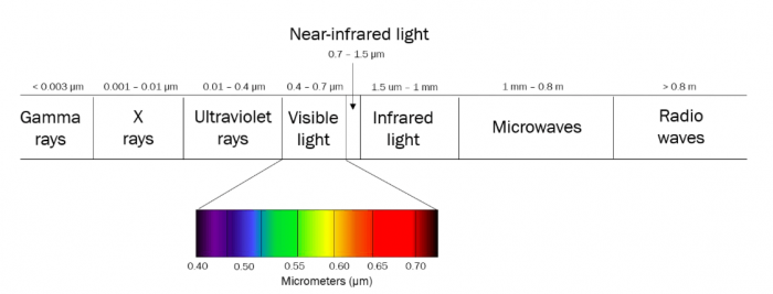
The sunlight that reaches the surface of our planet arrives as a spectrum of light with varying wavelengths. The absorption or reflectance of material the sunlight hits (e.g., the leaves on a tree) gives us its perceived color, since humans can only see a very small portion of the full light spectrum (Fig. 1). For example, chlorophyll, the photosynthetic material in plants, absorbs most of the red and blue light in the visible spectrum, making plants appear green.
Vegetation indices use reflectance ratios in defined spectral wavelength ranges (or bands) of a satellite image to provide an index for the vegetative biomass (e.g., Leaf Area Index [LAI]) at a location. Vegetation indices (VI) provide rangeland managers with accurate estimates of vegetative biomass, plant health, and landscape-scale changes across large or inaccessible areas with relatively little effort.

Figure 1. Electromagnetic spectrum of light. Image courtesy Rachel Fern
The Normalized Difference Vegetation Index (NDVI) is the most commonly-used vegetation index to represent standing vegetative biomass in terrestrial systems. This index uses surface reflectance values in the near-infrared (NIR) and red wavelength ranges where chlorophyll absorbs the majority of the light energy necessary for photosynthesis. However, because of bare soil in arid and semi-arid rangelands, NDVI estimates are often less accurate due to the interference of background soil reflectance. Regions with dry, sandy soils coupled with sparse vegetation generate high surface reflectance values and produce biased estimates of vegetation biomass and coverage. A newer VI, the Optimized Soil Adjusted Vegetation Index (OSAVI), accommodates high soil reflectance and adjusts the ratio of NIR and red reflectance by incorporating a background reflectance constant.
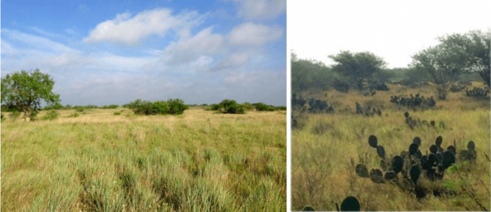
We evaluated the accuracy of vegetative biomass and coverage (bare-ground, herbaceous, and woody) estimates of NDVI and OSAVI in a semi-arid rangeland in south Texas. The Coloraditas Grazing Research and Demonstration Area (CGRDA) is a 7684-ha pasture located in the northern end of the San Antonio Viejo Ranch (SAV) of the East Foundation (Fig. 2). This is one of six properties of the East Foundation that are jointly managed to support wildlife conservation and other public benefits of cattle ranching and private land stewardship. This property is largely representative of the semi-arid south Texas rangelands and is predominated by low-growing woody plants, sparse herbaceous vegetation, dense shrubs (e.g., Honey mesquite, Catclaw acacia, Spiny hackberry, Texas snakewood, White-brush, Texas lantana) and cacti (Texas prickly-pear, Christmas cactus).

Figure 2. Typical vegetative landscape of San Antonio Viejo (SAV) Ranch, a semi-arid rangeland in south Texas. This property is located within the Rio Grande Plains, or “brush country”, encompassing the Coastal Sand Plain, Tamaulipas Thornscrub, and Lower Rio Grande Valley ecoregions of Texas. Image courtesy Rachel Fern
We classified remotely sensed imagery (Landsat 8-OLI) acquired in the summer of 2015 and 2016, along with NDVI or OSAVI, to generate estimates of each vegetative cover class (Fig. 3). These time periods coincided with the onset of a cattle grazing experiment (December 2015) in which each pasture of the CGRDA was treated with varying grazing intensities (i.e., animal stocking rates). We compared these remotely-derived estimates to those provided by traditional ground vegetation surveys. We also compared the classification accuracy (Maximum Likelihood) of images stacked with the NDVI or OSAVI as well as land cover (%) change between the two years (before and after the onset of cattle grazing).

Figure 3. Comparison of Landsat 8-OLI imagery encompassing a portion of the San Antonio Viejo (SAV) Ranch in south Texas in July 2015. Full spectrum (A) is compared to generated NDVI (B) and OSAVI (C). Value ranges also reported. Image courtesy Rachel Fern
For both years, images that were stacked with the OSAVI produced higher overall (all vegetative cover classes) classification accuracy than those stacked with the NDVI. OSAVI-derived estimates of herbaceous and woody vegetation were significantly more similar than NDVI-derived estimates to those from ground surveys in 2015 (pre-grazing). In 2016 (post-grazing), OSAVI-derived estimates of all three vegetative cover types were significantly more similar than NDVI-derived estimates to those from ground surveys.
Our results indicate the OSAVI to be a more appropriate VI-based indicator of green biomass and vegetative coverage in semi-arid rangelands, such as south Texas. Both indices were least accurate for the bare-ground coverage class. Spectrally identifying bare-ground can be challenging due to the presence of surface organic litter material or senesced plants.
However, monitoring changes in herbaceous or woody vegetation is usually a priority for rangeland managers. Free-use and timely satellite data are widely available and remotely sensed products (such as vegetation indices) can provide rangeland managers with a powerful, and cost-effective alternative to traditional ground survey methods for monitoring rangeland health and vegetation coverage over time. The OSAVI can be a reliable, accurate, time- and cost-effective tool for rangeland ecologists to inform management and monitor changes in vegetation under varying management practices, such as cattle grazing, or climatic events, such as periods of drought.
These findings are described in the article entitled Suitability of NDVI and OSAVI as estimators of green biomass and coverage in a semi-arid rangeland, recently published in the journal Ecological Indicators. This work was conducted by Rachel R. Fern, Elliott A. Foxley, and Michael L. Morrison from Texas A&M University, and Andrea Bruno from the East Foundation.


