


In cold regions, ice accumulation often affects navigation, flood control, water supply, power generation, and other human activities. Under extreme conditions, it can also result in an ice flood. Examples of ice breakup and ice sheet in Heilongjiang River are shown in Figures 1 and 2.
Therefore, in situ measurements of the ice conditions of rivers, lakes, canals, and reservoirs are important to mitigate and prevent ice disasters.
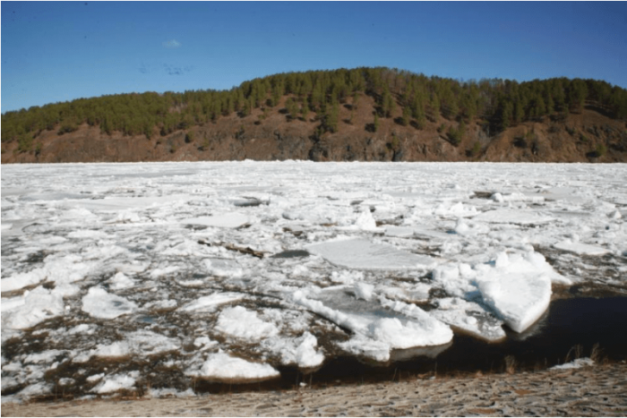
Figure 1: Beiji village, Heilongjiang River, China, where an ice breakup occurred. Credit: Hui Fu
Ice thickness and water depth are important parameters of such observations, and their measurement methods can be generally divided into two types: contact and non-contact measurements. Contact measurements include traditional drilling and the use of resistance heating line and pressure sensors. The non-contact measurement methods include sonar; remote sensing by satellite, airborne and ground-based radar; and ground penetrating radar (GPR).
There has been continuous improvement of the GPR measurement method in recent years, with the technology offering the advantages of compactness, low cost, and high efficiency. The GPR can also be dragged over long distances for ice condition measurements, so the GPR method is very suitable for ice measurement.
The principle of GPR is that high-frequency short-pulse electromagnetic waves are transmitted into the ice from the transmitting antenna of the radar system placed on the ground; the waves encounter underground formations or targets of differing electrical properties and are reflected back to the ground surface where they are received by the receiving antenna of the radar system (Figure 3). The dielectric constant of air is 1, that of water is about 80, that of ice is 3–4, and that of sandstone (silt) is 5–30. The differences among the dielectric properties of air, ice, water, and sandstone enable detection of layers between two materials with different dielectric permittivities using a GPR.
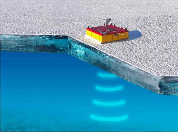
Figure 3: Basic principle of the use of a GPR to measure ice thickness and water depth. Credit: Xinlei Guo
In addition to ice thickness, the corresponding water depth of the measuring site is also needed because ice thickness is only one of the causes of ice jams or ice dams. For example, if the water depth is high enough, the ice can be transported easily in the river, so thicker ice does not always cause an ice jam or dam.
Although GPR systems are widely used for the measurement of ice thickness and water depth, the current single-frequency GPR is incapable of accurate simultaneous measurement of ice thickness and water depth. Of course, the water depth can be measured in the summer, but when you measure the ice thickness in the winter with a single-frequency GPR, it is hard to follow the same measurement route. In view of the shortcomings of the use of single-frequency ground penetrating radar (GPR) for simultaneous measurement of ice thickness and water depth, a double-frequency GPR with 100 and 1500 MHz antennas was developed (Figure 4).
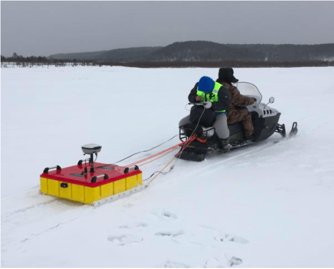
Figure 4: In situ measurement of double-frequency GPR in Mohe County section of the Heilongjiang River. Credit: Xinlei Guo
The advantage of double-frequency GPR is the simultaneous collection of ice thickness and water depth data. It also improves the efficiency of the observation process and can be seamlessly integrated with a GIS system for enhanced prediction and response to ice disasters. Through a time-sharing process, the system uses frequencies of 100 and 1500 MHz to measure water depth and ice thickness, respectively. The example of a measurement result is shown in Figure 5.
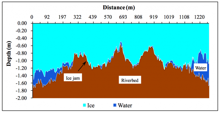
Figure 5: Measured ice thickness and water depth in the Longdao Wharf section of the Heilongjiang River, April 2016. The air temperature was about -10 °C, most reaches had snow on top. Credit: Hui Fu
Analysis of the data collected by the developed double-frequency GPR revealed that some factors that affected its ice thickness and water depth measurement accuracies were as follows. 1) The complex process of ice jamming produces ice jams with differing multilayered structures containing randomly distributed porosities. This alters the material’s dielectric constant, which is the basis of the measurement principle of the radar system. 2) Ice in a sandy river contains varying masses of sediment, with additional sediment transported by the water at the bottom of the river. This is one of the factors that influence the dielectric constants of the water and ice, and, hence, the measurement accuracy of GPR.
These findings are described in the article entitled Double-frequency ground penetrating radar for measurement of ice thickness and water depth in rivers and canals: Development, verification and application, recently published in the journal Cold Regions Science and Technology. This work was conducted by Hui Fu, Zhiping Liu, Xinlei Guo from the China Institute of Water Resources and Hydropower Research, and Haitao Cui from Dalian Zhongrui Science and Technology Development Company.
Related Posts
 Duck-Billed Dinosaurs Uncovered In Aniakchak, Alaska
 Cryptic Diversity In Vietnam’s Limestone Karst Habitats
 An Improved Method To Remove Debris From Cyst Nematode Egg Suspensions And Computer-Aided Technologies For Egg Counting
 The Footprints Of Urbanization, Industrialization, And Agriculture On River Beds: Heavy Metal Contamination Assessment And Source Identification In River Sediments In Eastern China
 Aging Dolphins Via Pectoral Flipper Radiography
 Glycoalkaloids In Potatoes: The Effect Of Biostimulants And Herbicides