As a special resource, sand is widely distributed in China, especially in arid and semi-arid regions. Because of the effects of a region’s geographic environment, districts that are abundant in sand are vulnerable to desertification. At the same time, some unreasonable ways of utilizing sand have also led to a vicious circle of “development – desertification – abandonment – severe desertification.”
As the increase of population puts pressure on the development of society and economy, the question of how to make full use of sand is attracting more and more people’s attention. At present, the academic circles’ research on land desertification is mainly focused on several issues, including desertification driving forces, evaluation, dynamic monitoring, comprehensive prevention and control, etc. However, the research on assessment for appropriate tillage is limited. And establishing the principles, indexes, and methods to select the arable sand from the sandy land is the basis of sustainable development of sandy land.
The authors of this paper selected the Hangjin Banner, which is located in Inner Mongolia, as a research area. Remote sensing (RS) and Geographic information system (GIS) technologies were applied to explore proper methods for appropriate tillage.The research results are as following:
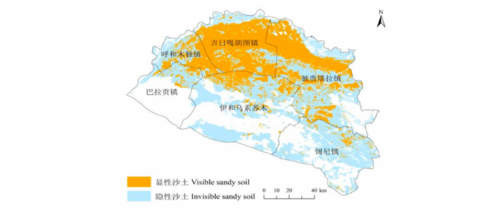
(1) All sandy soil was considered as evaluated objects of appropriate tillage, including visible sand land and invisible sand land. According to the classification of current land use, the visible sand land is the sand land area. Invisible sand is the texture of the sandy soil, including cultivated land, forestland, grassland, construction land, marshland, inland beaches, and alkaline land.
(2)Based on the productive and protective principles, an evaluation index system was established. The system is also the most essential part of this paper, which includes land use/cover, ecological conditions, irrigation conditions, soil salinization, and pH conditions. For the land use/cover, to get the vegetation fraction, OLI-TIRS images were processed with the support of band math. Then, the results were classified according to the technical code of practice on the sandy land monitoring.
The grassland that indicated Vegetation fraction (VFC) below 10% is suitable. Meanwhile, alkaline land, inland beaches, semi-fixed dunes, and fixed dunes are also suitable. As for the ecological and water resource, ecological protection areas are not suitable. Places where annual precipitation falls below 350 mm and irrigation is hard are also unsuitable. Land that has severe salinization and strong alkaline also shouldn’t be considered.
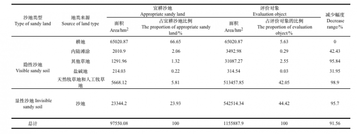
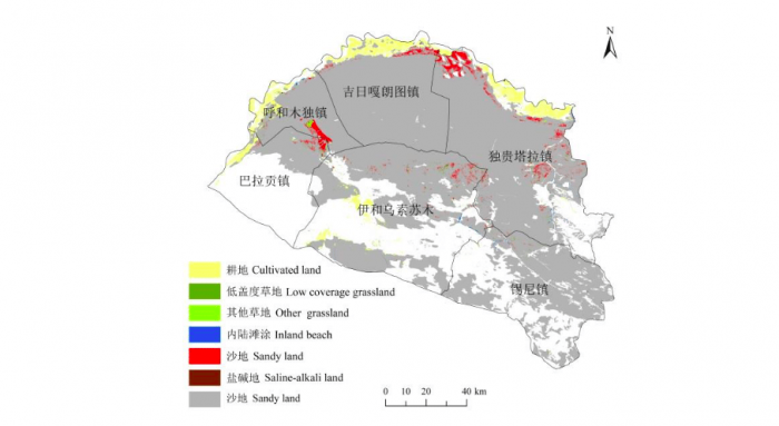
(3) To determine the ultimate arable sand land, the author filtered all sandy soil by means of limiting factors in turn. The sand land area of Hangjin Banner is 1.2×10⁶ hm2. The percent of the visible sand land is 42.55% and invisible sand land is 57.45%. The percent of the arable sand land is 7.65%, including sand land, cultivated land, the least vegetation-covered grassland, other grassland, inland beaches, and alkaline land.
(4) To achieve sustainable development after reclamation to arable sand land, it is necessary to implement exploitation and construction projects and field management measures according to types and properties of arable sand land. This paper could provide support for survey and evaluation for appropriate tillage sand land.

杭锦旗宜耕沙地调查评价结果
The result of survey evaluation for appropriate tillage sandy land. Credit: Yan Xu

Credit: Yan Xu

宜耕沙地类型及空间分布
Type and spatial distribution of appropriate tillage sandy land. Credit: Yan Xu
These findings are described in the article entitled Evaluation of land reclamation and implications of ecological restoration for agro-pastoral ecotone: case study of Horqin Left Back Banner in China, recently published in the journal Chinese Geographical Science. This work was conducted by Jian Zhou from Shaanxi Normal University, and Fengrong Zhang, Yan Xu, Yang Gao, and Zhen Xie from China Agricultural University.


