


Welcome to the My Science Life submission by Muhammad Akram Khan, freelance Hydrologist from Pakistan. The ‘My Science Life’ project is a core part of Science Trends’ mission to communicate science. It is an opportunity for people, like yourself, to share the knowledge you’ve built up over the years without the endless peer reviews.
Interested in being part of the My Science Life project? You can find the details about submission here.
Introduction
Balochistan by virtue of its already known and partly developed natural resources is in a favorable position to offer sites for power development by utilizing natural gas. Gas-fired power generation gains even added importance in the absence of hydro and nuclear energy resources in the province.
The importance of exploration and evaluation of new gas resources has acquired added importance due to the recent developments in the electric power sector to recover the shortfall requirements. This has further necessitated exploration of natural resources in the areas buried under the alluvial cover, to sustain natural gas supply to different industries in the foreseeable future.
The main objective of the present job is to give eco-environment attention in parts of Uch gas field as well as to do a detailed evaluation of the promising existing gas reservoirs for their better utilization. In this connection it will be necessary to generate a lot of new and dependable data by preparing large scale maps, undertaking sedimentological, paleontological, stratigraphic and structural/tectonic studies and carrying out an appropriate data.
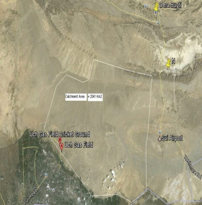
The project area lies in the northeastern portion of an extensive plateau of the Balochistan province, having a rough surface and divided into basins by ranges of high mountainous belts, sharply divided from the Indus plain by the Suleiman, Kirthar and Pub Ranges. There are three sizable plains in the province namely Kachi, Lasbela, and Dasht.
The project area is situated in the Kachhi plain which consists of a flat valley in the middle of various ranges.
Tectonic Features, Geology, Stratigraphy, Topography, & Soil
The continental collision between the Indian and Eurasian plates and the subsequent formation of orogenic highlands (Himalayan, Kandahar, and Kohistan etc.) represent tectonic and depositional processes that have molded the Cenozoic geology of Western and Central Pakistan. The Himalayan Forelands display distinctive lithological development that characterizes the northern Upper and the southern Lower Indus basins.
The lower Indus Basin is divided west-east into Kirthar and the Suleiman geological provinces by the Khairpur-Jacobabad High and the Quetta syntaxes. A prominent feature associated with these geological events are the Oligocene sedimentary hiatus which long been interpreted as an erosional unconformity (e.g. Downing et al. 1993). Only the southernmost Kirthar geological province, less affected by tectonics, documents well-developed transgressive marine Oligocene sediments (Nari Formation), gradationally influenced by fluvial beds of the overlying Miocene Manchar Formation (Raza et al 1984). The early Miocene Gaj Formations, interpreted as the oldest Geological record of the Indus delta, have led to the description of the Paleogene siliciclastic Khojek Formation in the Katawaz Basin due to recent investigations (eastern Makran).
In the Suleiman Geological province, the Bugti Hills (eastern Balochistan, southern Suleiman ranges, Suleiman lobe) represent an important record of Himalayan foreland sediments, which have yielded the richest fossil land vertebrate faunas to be found in South Asia.
In the Kirthar and Suleiman provinces, the Middle to Upper Eocene deposits consists mainly interbedded carbonates and shale of the marine Kirthar Formation. From the base to the top, this formation comprises the Habib Rahi Limestone member, the Domanda Shale member, the Pir Koh Limestone member and the Drazinda Shale member in the Suleiman Ranges, the Kirthar formation is disconformably overlain by Chitarwata Formation. Nevertheless, a Late Oligocene to Early Miocene age originally considered on the basis of the palyno-assemblage from the Toi Nala section. The Bugti area displays equivalents of the Kirthar and Chitarwata Formation. In addition, the upper most member of the Kirthar Formation ( Drazinda Shale) is conformably and transitionally overlain by the lowermost level of the Oligocene marine Nari Formation. The level is predominantly composed of the white to gray massive crystalline limestone of the Nal member, which yields the typically Oligocene neritic.
The project area is surrounded by Sibi Trough OR Sibi syntaxis, Kirthar and central Bolan range on the west and in the north, by steeply sloped Zin Range of Murree and Bugti hills (an extension of southern Suleiman axial belt, Suleiman Lobe of eastern Baluchistan) while east and south is Indus plain. Other ranges dressing the area are low hills called Pabs.

(Authors for references: – Jean-Loup Welcome*, Mouloud Benammi*, Jean-Yves crochet*, Laurent Marivaux*, Gregoire Metais*, Pierre-Olivier Antoines and Ibrahim Baloch).
- Stratigraphic Sequence of Well No. 21 of the Project Area is at 1.
The project area is located between latitudes 68, 30, 02-69, 00, 00N and longitude 28, 45, 00-29, 00, 00E.
Topographically the area can be explained as a virgin part of the barren Piedmont plain with gentle slopes from north to south at an elevation 600-3200 feet above from the sea level, mainly formed by the deposition of fine sediments, transported by widely spread floods originating from the surrounding hills during the Quaternary age. The parent source material is of limestone, shale, sandstone and conglomeratic sedimentary nature’s fine grain particles of the source rocks. An isolated out crops of Siwaliks sandstone are commonly exposed in the project area.
Credit: Google Earth
Hydrological Set-up
Baluchistan is the largest province of Pakistan with very limited water resources. Only about 2% of the total area is under cultivation due to the scarcity of water. Agriculture mainly depends on rainfall available during October to February; however, wide fluctuation has been recorded. The distribution of rainfall is very erratic, irregular and difficult to predict with periods of extreme drought. Meteorological Station has recently been installed within the jurisdiction of Plant Area but no rain fall gauges are established since for. In the total catchment project area covering about 2041 km2, no perennial/non-perennial major streams are observed except at 28, 64,962N, 68, 57, 584E with a negligible quantity of seeped water from highland hills. Available Meteorological data provided is at Table?
In the project area, the bodies of running water originating from hill peaks and moving to a lower level in a channel on land are:
- Han
- Jagani
- Baghi
- Jangjiahi
- Siahaf
- Iliasi
The only source of water supply to Gas Plant and Residential Campus is from Pat Feeder Canal, which off takes from the right bank of Indus River at Guddu barrage. Bulk Reservoir and Daily use pond are constructed within the jurisdiction of Gas Plant having 1, 22,000 gallons and 22,000 gallons storage capacity respectively at 28, 65,412 N and 68, 57,597E. The waste Water reservoir is built up at X 463589 and Y 3164276. Data of total consumption of water used for Plant and Residential Campus was not available.
Nonexistence of most commonly used Irrigation System in Baluchistan Province “Karezes” indicates very poor under ground water potential. The project area comes within with very low rainfall eastern zones of the province and only I No; dried earthen pond in the vicinity of Gas Well No;13 located at 28,63,723N,68,62,782E is found.
For local community FC drilled 3 No; tube well in the outside localities.2 Nos; are converted into production wells while 1 No; was declared abandoned for the reason of poor quality/nonavailability of water.
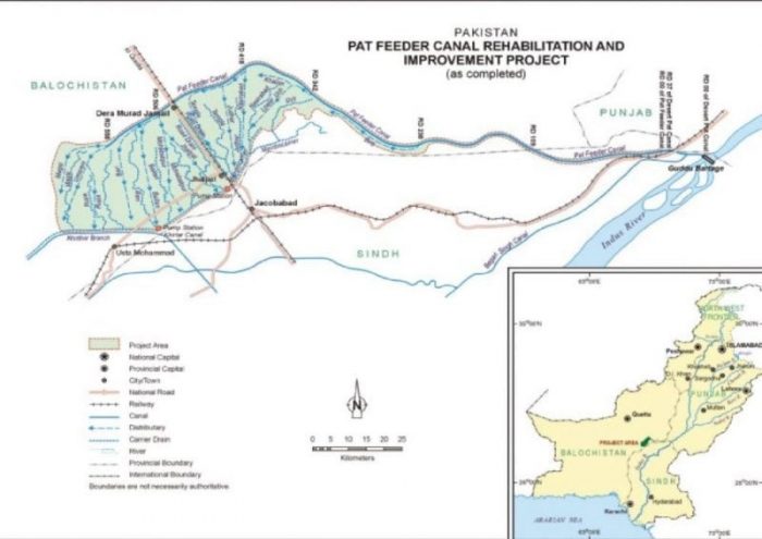
Pat Feeder Canal is the main source of the perennial surface water channel in the project area.
This is a branch of Desert Pat Feeder Canal which off takes from the right bank of Indus River at Guddu barrage. Water from this canal is used for agricultural purposes in Balochistan province. This canal was constructed between 1963 and 1969 by WAPDA and started operation in 1970. The last remodeling, to increase its capacity by nearly100 m3/s, was completed in 1997-98. The total length of the canal is 170 km and has a present design discharge of about190 m3/s. (6700 cubic feet per second (cusecs). The total cultivated command area (CCA) of the canal is about 458,425 hectares (132,788 acres) with a network set-up of 13 distributaries and 164 minors. The canal, except for a closure/maintenance period of about one month, is perennial. Highest discharges in the Pat Feeder Canal are recorded in June, July, and August. Minimum discharge is reported in December and April which is also the canal closure period.
The non-perennial Rabi canal, operating only in the Rabi season, is a branch of Pat Feeder Canal and has a total length of 47 km. It was completed in June 2002 and has a design discharge of 9.9 m3/s (350 cusecs).The canal serves 20,234 hectares (50,000 acres) of CCA, including areas surrounding the power plant.
Limited and quantitative rainy streams flow originating from Dera Bugti hills are another source of surface water. The team could not inspect the project area freely due to security risk
Water quality
Surface Water
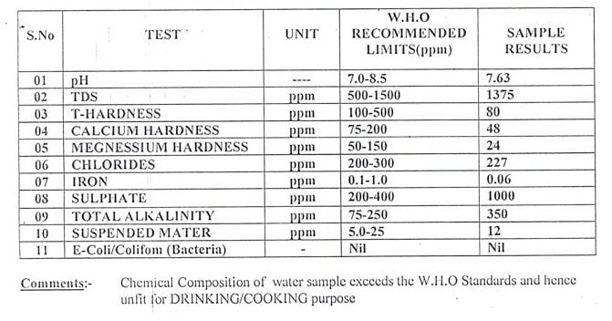
The quality of the Indus River water is highly dependent on river flow. It is chemically acceptable for agricultural use; however ignorable bacteriological contaminants and suspended solids (e.g., sediment) are present. Typical suspended solids and turbidity are lowest in December to February and increase from March – October depending on floods feeding. Water mineralization (i.e., total dissolved solids) is generally moderate with low change ratio. pH ranges from 7.0 to 8.5. Water temperature also varies from 15°C to 37°C.
Generally good water quality is reported from samples taken from Pat Feeder Canal and is useable for irrigation while for domestic purposes, inferred from the result, the results of the sampling and analysis for various water quality parameters along with comparison with guideline values such as World Bank/IFC and NEQS standards for discharge into inland waters is provided in table.
It is inferred from the results that values of most of the water quality parameters are below the guideline values, but this does not suggest that the water of the canal is fit for drinking purpose as well, as the guideline values are used as a pre-cursor for effluent discharge to the inland water bodies only.
The microbial test results have shown the presence of total coliforms indicating that the water is unfit for drinking without treatment.
Groundwater resources
The Kachhi Plain is made up of unconsolidated recent deposits (Geologically Speaking) of several hundred meters thickness. The dominant component is clay, appreciable amounts of gravels, clayey silts, and minor sand. The unconsolidated deposits constitute the major groundwater reservoir in the region. Groundwater use in the region is predominantly limited to the alluvial plain areas at the head of the Kachhi Plain. WAPDA installed 18 test holes and 14 tube wells in the plain during a groundwater investigation study of the area. The groundwater potential of an extensive area from roughly Jacobabad to Sibbi has been characterized by WAPDA to yield less than 10 cubic meters per hour per screened meter down to a level of at least 150 m (492 ft). The aquifer is described as poor and patchy. This zone of low potential extends from Jhatpat to Sibbi and includes all of the areas of the proposed site near Dera Murad Jamali. This aquifer is not capable of sustaining a reliable water supply to serve any purpose.
During the construction of Pat Feeder Canal, the study of the groundwater resources carried out has shown that the water table in larger part of the area ranges from 8 to 15 m below the natural ground surface. The water table would take about 25 to 30 years rise to within 2.5m of the surface. Recharge to groundwater is principally due to infiltration of precipitation falling within the basin. However, after the construction of an irrigation network, canal water infiltration is a significant source of recharge.
Groundwater quality
Total dissolved solids (TDS) contents in the upper groundwater aquifer are greater than 3,000 parts per million (ppm). The water is brackish in taste. The UNDP study reports TDS levels greater than 5,000 ppm near the site. Uch Power Limited (1990) notes that well water is very brackish with a TDS of 30,000 ppm near the site. Detailed information about aquifer productivity and the quality of water from possible aquifers below the upper water-bearing unit(s) is limited; however, all reports indicate the aquifer is highly mineralized, with low transmissivity, and discontinuous in nature.
Of such poor quality, groundwater is not economically viable to pre-treat it for industrial use. Large pockets of land to the south of the project site near Jacobabad exhibit serious problems of waterlogging and salinity. These problems result from the application of irrigation water to soils combined with the high evaporation rate of the dry climate. The high evaporation rate in the region enhances this potential use of evaporation ponds for the project.
Related Posts
 Be Careful When Speaking About Lead Pollution: The Good, The Bad, And The Ugly!
 Temperature Has A Significant Influence On The Production Of SMP-Based Dissolved Organic Nitrogen (DON) During Biological Processes
 Does The Arrow Of Time Apply To Quantum Systems?
 Labeled Periodic Table
 A “Twist” In Wavefunction With Ultrafast Vortex Electron Beams
 Chemical And Biological Characterization Spot The Faith Of Nanoparticles