


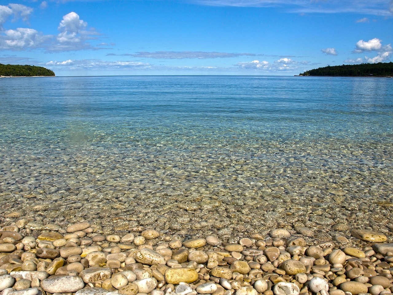
The Great Lakes are an important resource to the population living in the US and Canada. They provide drinking water and feed the agricultural lands. However, nutrient-loading into Great Lakes has produced several problems including, but not limited to, algal bloom, degraded water quality, and disturbed ecosystems.
Rowe et al. (2017) have shown that nutrients have increased the productivity of Lake Michigan; however, the invasive quagga mussels have altered spatial and temporal productivity patterns in the lake. This has significantly changed chlorophyll-a concentration in the lake. Irregular growth of algae in Lakes Erie, Michigan, and Ontario has been observed (Auer et al., 2010; Higgins et al., 2008; Tomlinson et al., 2010). Algal bloom is another consequence of excessive nutrients in the lake. Cladophora biomass has increased significantly in Lake Michigan nearshore zone due to increasing background phosphorous concentration in the lake that comes from the wastewater treatment plants (Bravo et al., 2017; Khazaei et al., 2017).
A very important example of environmental issues in Lake Michigan is Green Bay, connected to the western bank of Lake Michigan. Green Bay has been designated as an area of concern by US Environmental Protection Agency and is suffering from water quality problems because of high sediment concentration in the bay. Suspended sediments cause oxygen depletion and hypoxia in the Green Bay (Klump et al., 2009) which can endanger aquatic life. Additionally, reduced water quality and turbid water are claimed to be the result of high sediment concentration in the bay.
Our analyses show that the variability of water quality parameters (e.g. chloride, total phosphorous, ortho-phosphorus, total Kjeldahl nitrogen, ammonia, chlorophyll-a, and turbidity) in Green Bay and mouth of the Fox River is highly correlated to sediment concentration.
Fox River is the largest river flowing into Green Bay and known to be the main source of sediments/pollutants to the bay. It is about 320 Km long and drains an area of 16,651 km2. It carries sediments from Lake Winnebago, in Wisconsin, and other land-based pollutants that join the river in its midway to the southern Green Bay. Because of the paper-producing companies in the area, large concentrations of polychlorinated biphenyls (PCB) can be found in the mouth of the Fox River (Manchester-Neesvig et al., 1996).
Wind-induced waves and currents in Lake Michigan – including Green Bay – take the most responsibility of mixing (Mortimer 1988, Eadie et al. 1996). However, Green Bay has shallow water depth and low mixing rates (Hamidi et al., 2015), that does not let the sediment be transported into Lake Michigan, which made Green Bay an efficient sediment trap.
These facts given above have initiated efforts to monitor water quality and sediment concentration in the Lower Green Bay and Fox River turbid plume. These efforts include filed monitoring and observations combined with modeling and computational analysis. NEW Water of Green Bay started the Aquatic Monitoring Program in the mid-1980s. NEW Water takes samples of water in 34 stations located along Fox River, East River, and Lower Green Bay. They have analyzed the samples and measured TSS since 1991. They also measure other water quality parameters in this area, e.g. chloride, total phosphorous, ammonia, chlorophyll-a, turbidity, etc.
There have been intense research and computational efforts since the 1980s to monitor water quality in Green Bay and develop restoration plans. In addition, there are daily measurements of turbidity since 2011 at the mouth of Fox River measure by the United States Geological Survey. In an ongoing study, we are developing a model that can convert turbidity time series into a continuous TSS daily estimates (Khazaei et al., 2018). This can help to figure out the effects of Fox River loadings on Green Bay’s water quality. Our analyses show that Fox River is roughly discharging an average of 300 tons of sediments per day into Green Bay.
Apparently, sediments suspended in surface water can be detected by satellites orbiting around the earth. Figure 1. represents Lower Green Bay satellite imagery. As it can be seen, the color of water seems different in different locations of the bay. Brighter colors in the southern part of the bay, where the mouth of Fox River located, are due to the existence of sediments.
Hamidi et al. (2017a; 2017b) used this characteristic of sediments to developed a monitoring tool that can estimate TSS and turbidity based on space-borne imagery data with correlations of more than 80%. Using empirical functions, surface reflectance of the satellite imagery data acquired by NASA’s MODerate Resolution Imaging Spectroradiometer (MODIS) were attributed to the NEW Water’s observations of TSS and turbidity at the surface of the lake. Suggested model can be expanded to provide estimates of chlorophyll-a as well since this is an optically active variable and can be detected by satellites.
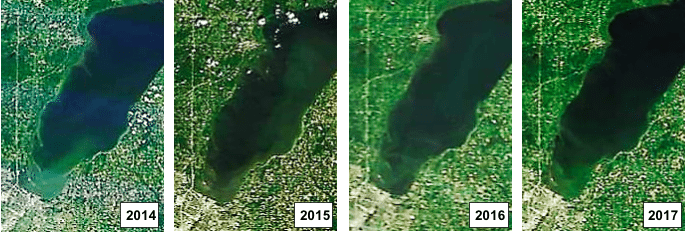
Figure 1. Turbid plume in Green Bay near the mouth of Fox River in August of 2014, 2015, 2016, and 2017 years based on MODIS satellite imagery.
This model has provided a computational tool to monitor patterns of TSS variability in time and space without having to go through all previous sampling and measurement efforts. Given the above and the increasing population of satellites in Earth orbit, remotely sensed data are becoming more available day by day. The approach of this study, presented herein, is expandable to other aspects of water quality modeling.
Models of similar essence can help environmental assessment programs by providing estimates of water quality parameters in large geographical scales. Except for cases that imagery data are contaminated with clouds, MODIS data is available in daily temporal resolutions, hence, it can be used to assess the desired variables when there is a gap in observations. Moreover, sometimes scientists are interested in an event in the past and there is no observational data available for that event. In this case, satellite data, if available, can be utilized to model that event.
These findings are described in the article entitled Using MODIS remote sensing data for mapping the spatio-temporal variability of water quality and river turbid plume, recently published in the Journal of Coastal Conservation. This work was conducted by Sajad Ahmad Hamidi from the Indiana University of Pennsylvania, Hossein Hosseiny from Villanova University, Nima Ekhtari from the University of Houston, and Bahram Khazaei from the University of Wisconsin-Milwaukee.
References:
-
- Auer, M.T., Tomlinson, L.M., Higgins, S.N., Malkin, S.Y., Howell, E.T. and Bootsma, H.A. 2010. Great Lakes Cladophora in the 21st century: same algae—different ecosystem. J Great Lakes Res, 36: 248–255.
- Bravo, H.R., Bootsma, H.A. and Khazaei, B. 2017. Modeling the transport and fate of phosphorus from a point source in the Lake Michigan nearshore zone. Proceedings of the 37th IAHR World Congress, Kuala Lumpur, Malaysia, 13-18 Aug.
- Eadie, B.J., Schwab, D.J., Leshkevich, G.A., Johengen, T.H., Assel, R.A., Hawley, N., Holland, R.E., Lansing, M.B., Lavrentyev, P., Miller, G.S., Morehead, N.R., Robbins, J.A., and Van Hoof, P.L. 1996. Recurrent Coastal Plume in Southern Lake Michigan. EOS, Trans. Amer. Geophys. Union, 77: 337–338.
- Higgins, S.N., Malkin, S.Y., Howell, E.T., Guildford, S.J., Campbell, L., Hiriart-Baer, V., Hecky, R.E. 2008. An ecological review of Cladophora glomerata (Chlorophyta) in the Laurentian Great Lakes. J Phycol, 44: 839–854.
- Hamidi S.A., Bravo, H.R., Klump, J.V. and Waples, J.T. 2015. The role of circulation and heat fluxes in the formation of stratification leading to hypoxia in Green Bay, Lake Michigan. J Great Lakes Res 41(4): 1024–1036.
- Hamidi, S.A., Hosseiny, H., Ekhtari, N. and Khazaei, B. 2017. Using MODIS remote sensing data for mapping the spatio-temporal variability of water quality and river turbid plume. J. Coast. Conserv, 21: 939–950.
- Hamidi, S.A., Hosseiny, H., Ekhtari, N. and Khazaei, B. 2017. A Satellite Imagery Approach to Monitor Turbidity and Total Suspended Sediments in Green Bay, WI. Abstract [GC23B-1066] presented at 2017 Fall Meeting, AGU, New Orleans, LA, 11-15 Dec.
- Khazaei, B., Bravo, H.R. and Bootsma, H.A. 2017. Using a hydrodynamic and biogeochemical model to investigate the effects of nutrient loading from a wastewater treatment plant into Lake Michigan. Abstract [B43B-2123] presented at 2017 Fall Meeting, AGU, New Orleans, LA, 11-15 Dec.
- Khazaei, B., Nabizadeh, A. and Hamidi, S.A. 2018. An Empirical Approach to Estimate Total Suspended Sediment using Observational Data in Fox River and Southern Green Bay, WI. World Environmental and Water Resources Congress 2018. Protecting and Securing Water and the Environment for Future Generations. ASCE.
- Klump, J.V., Fitzgerald, S.A. and Waples J.T. 2009. Benthic biogeochemical cycling, nutrient stoichiometry, and carbon and nitrogen mass balances in a eutrophic freshwater bay. Limnol Oceanogr, 54(3): 692–712.
- Klump, J.V., Edgington, D.N., Sager, P.E., and Robertson, D.M. 1997. Sedimentary phosphorus cycling and a phosphorus mass balance for the Green Bay (LakeMichigan) ecosystem. Can J Fish Aquat Sci, 54(1): 10–26.
- Manchester-Neesvig, J.B., Andren, A.W. and Edgington, D.N. 1996. Patterns of mass sedimentation and of deposition of sediment contaminated by PCBs in Green Bay. J Great Lakes Res, 22(2): 444–462.
- Mortimer, C.H. 1988. Discoveries and testable hypotheses arising from Coastal Zone Color Scanner imagery of southern Lake Michigan. Limnol Oceanogr, 33: 203–266.
- Rowe, M.D., Anderson, E.J., Vanderploeg, H.A., Pothoven, S.A., Elgin, A.K., Wang, J. and Yousef, F. 2017. Influence of invasive quagga mussels, phosphorus loads, and climate on spatial and temporal patterns of productivity in Lake Michigan: A biophysical modeling study. Limnol Oceanogr, 62: 2629–2649.
- Tomlinson, L.M., Auer, M.T., Bootsma, H.A. and Owens, E.M. 2010. The Great Lakes Cladophora Model: Development, testing, and application to Lake Michigan. J Great Lakes Res, 36: 287–297.
Related Posts
 Duck-Billed Dinosaurs Uncovered In Aniakchak, Alaska
 Cryptic Diversity In Vietnam’s Limestone Karst Habitats
 An Improved Method To Remove Debris From Cyst Nematode Egg Suspensions And Computer-Aided Technologies For Egg Counting
 The Footprints Of Urbanization, Industrialization, And Agriculture On River Beds: Heavy Metal Contamination Assessment And Source Identification In River Sediments In Eastern China
 Aging Dolphins Via Pectoral Flipper Radiography
 Glycoalkaloids In Potatoes: The Effect Of Biostimulants And Herbicides