Nature plays an important role in human activities. It is considered an important capital and is crucial for the development of the economy and social wellbeing. Nature capital is the base of human existence, however, this value has not been considered in national wealth.
Ecosystem services (ES) are defined by the benefits that ecosystems provide to humans (MA, 2005). They are divided as provisioning, regulating, and cultural ES. Provisioning ES are the products obtained from the ecosystems such as food, timber, energy, fresh water, etc. Regulating services are the ones that are important for earth’s functions, such air pollution regulation, climate regulation, flood regulation, water purification, etc. Cultural ES are connected with human activities such as recreation, spirituality, aesthetic, leisure etc. Valuating the ecosystems and their services contributes to raising awareness about their importance, as the protection of the habitats that provide it. In addition, quantitative data is available to decision and policy makers to take into account the ecosystems and their services (Science for Environment Policy, 2015).
Nowadays, the intensive exploitation of ecosystems (e.g. urban sprawl, intensive agriculture and fish stocks exploitation and deforestation) is leading to a cumulative effect in the environment. This is causing an important loss of the ecosystems and their services.
- Currently, approximately 1.2 billion people live in areas affected by severe water stress and 795 million people are affected by hunger.
- One-third of the world deaths are a consequence of high levels of air pollution.
- Deforestation and agriculture are responsible for approximately 25 % of the global greenhouses emissions.
- It is estimated that every year, 8 million metric tons of plastic waste and 80% of the world’s wastewater is sent to the oceans without any treatment.
The facts mentioned above are worrying, and for a correct understanding of the value of the ecosystems and to mitigate our impact on the environment, a correct assessment is required. In this context, it is crucial to have a sustainable approach in the way we manage the land at different scales. ES analysis and assessment contributes to this understanding and it is fundamental for stakeholders and policymakers to have a better comprehension about the synergies and trade-offs between ES and the importance of biodiversity in this domain (Science for Environment Policy, 2015).
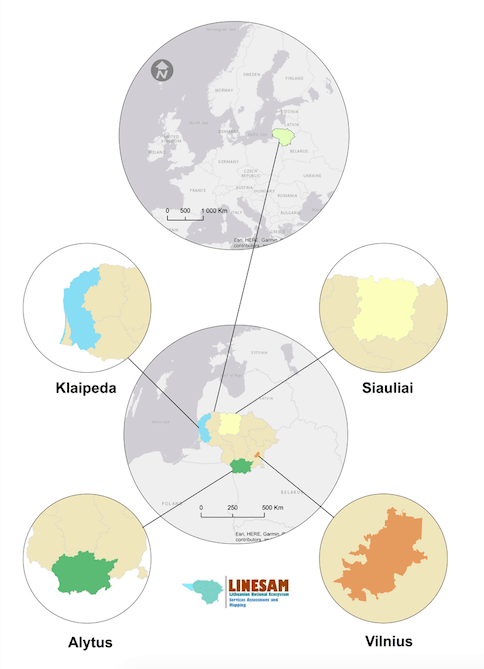
Mapping ES is an easy and effective way to provide information to decision-makers and stakeholders and is important to examine the trends in ES and the drivers of changes that may affect them, optimizing ES and biodiversity, identify the trade-offs and synergies between ES, observe the spatial distribution of supply and demands and evaluate the cost and benefits of maximizing ES (Science for Environment Policy, 2015). The idea of the mapping ecosystem services in Lithuania (LINESAM) (Figure 1) born from the need to have a better understanding about ES and provide relevant information to stakeholders and policymakers to incorporate in spatial planning at different scales (national, regional and local). LINESAM is planned to be implemented from 2018 to 2021 and is financed by Lithuanian Research Council (European Social Fund according to the activity ‘Improvement of researchers’ qualification by implementing world-class R&D projects’ of Measure No. 09.3.3-LMT-K-712)

Figure 1: Study areas. Credit: Paulo Pereira
The aims of the project are:
- “Development of a national ES mapping and assessment framework to improve the understanding of the relationships between ecosystems, biodiversity and human well-being and how drivers of change may affect ES supply in Lithuania;
- “Assessment and mapping across ecosystems (urban areas, agricultural, forested and coastal/marine environments)“;
- “Assessment and mapping across spatial scales (national level and case study specific) using the Common International Classification of Ecosystem Services (CICES) class types. Through a stakeholder engagement process, we will identify the actual beneficiaries of ES and their power relations“ (Pereira et al. 2018);
The specific aims of the project are 1) “to improve the understanding of nature-society interaction through an ES based approach“, 2) Identify national drivers of change (environmental and socio-economic) and their effect on ES supply and demand, 3) “Support the development of planning and management strategies grounded on socio-ecological principles of ecosystems and biodiversity”, 4) “Common knowledge baseline on ES, accessible to decision-makers, planners, academics and the public” and 5) “Development of a Geoportal, based on open source technologies that will support storing, sharing and mapping of the results throughout the project lifetime”.
The project will assess and mapping terrestrial, freshwater and marine biomes in Lithuania. Four case studies were selected to perform more detailed ES analysis: 1) Urban (Vilnius city), 2) Crop production (Siauliai region), 3) Wood provisioning (Alytus region), 4) Coastal/Marine (Klaipeda region) (Pereira et al. 2018).
The information created in this project will be delivered in a Geoportal with the objective to share the information with the stakeholders, produce and increase the knowledge about ES mapping and assessment in Lithuania.
References:
- MA (2005) Ecosystems and Human Well-Being: Synthesis. Island Press, Washington, DC.
- Science for Environment Policy (2015) Ecosystem Services and the Environment. In-depth Report 11 produced for the European Commission, DG Environment by the Science Communication Unit, UWE, Bristol. Available at: http://ec.europa.eu/science-environment-policy
- Pereira, P., Misiune, I., Miksa, K., Kalinauskas, M. (2018) LINESAM: Incorporating ecosystem services knowledge into geospatial content management systems in support of environmental management planning. In: LIFE VIVAGRASS International Seminar “Integrating ecosystem service concept into spatial planning – for sustainable land-use in grasslands and beyond” 16-18 May 2018, Sigulda, Latvia


