A major event of the Cenozoic history of the Earth was a collision of the African–Arabian and Indian plates with Eurasia. It led to the raising of the Alpine Fold Belt and, in the closure of the Tethyan Basin, connecting the Atlantic and Indian oceans.
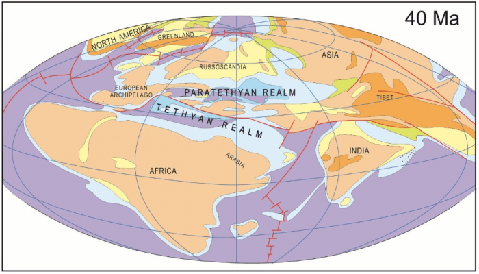
Fig 1. Tethyan and Paratethyan realms at middle Late Eocene time 40 Ma. Figure courtesy Sergej V. Popov
The region under consideration includes the central Crimean-Caucasian part of the Alpine Fold Belt, which stayed tectonically active during the Paleogene – Neogene and passive margin of the East European Platform. At the first part of the Paleogene, the Caucasian – Kopetdagh Sea occupied this region, and it remained open to the Atlantic, as well as the south Iran-Anatolian basins and the Indian Ocean.
From the beginning of the Oligocene, this deep-water basin, named the Paratethys, became an intracontinental sea, characterized by unstable salinity, hydrological, and oxygen regime. It gradually lost its free connections with the World Ocean (Popov et al., 2004). Foraminifers, ostracods, diatoms, nannoplankton, corals, mollusks, and fish inhabited these basins; these were preserved as fossils. A stratigraphic scheme of the Paratethys based on these organic remains is historically viewed as the first of mollusk evolution (Popov, Golovina [eds.], 2016). In unstable environments of semiclosed basins, they either sharply decreased in number and became extinct or gave rise to numerous endemic species, genera, and families (fig. 2).
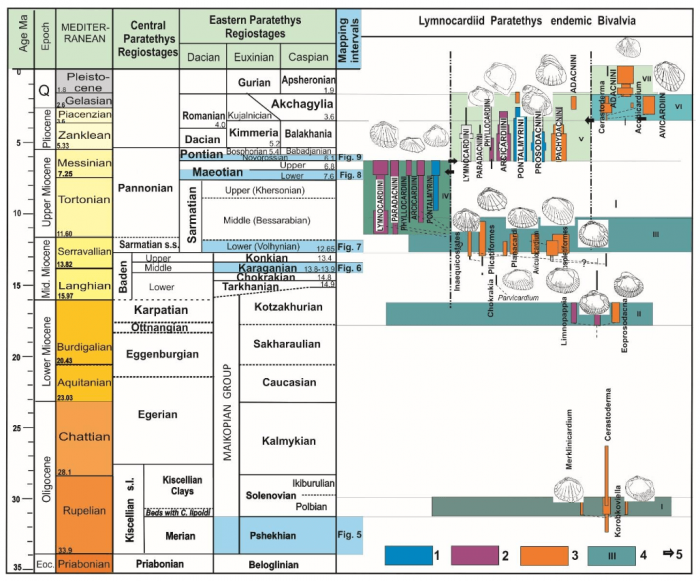
Fig. 2. Stratigraphic scheme of the Oligocene – Neogene Paratethys, their correlation with the Mediterranean and stratigraphic distribution of the lymnocardiids (Bivalvia, Cardiidae). Legend: 1 – endemic triba of Mediterranean origin; 2 – Central Paratethys origin; 3 – Eastern Paratethys origin; 4 – living time of the main endemic groups of this interval; 5 – invasions from neighbor basins. Figure courtesy Sergej V. Popov
In this publication, we present paleogeographic maps that summarize drilling, seismic, and other data from multidisciplinary research.
1. Maikopian basin (Oligocene – early Miocene)
The first isolation of the Paratethys due to uplifting in the Alpine – Dinarids – Caucasus – Kopetdagh mountain belt, as well as deepening of the basin bottom and the terminal Eocene cooling, led to thermohaline water stratification and to a primarily estuarine water circulation pattern, resulting in stagnation and accumulation of dysoxic to anoxic sediments (“maikopian and menilitic faces”).
Maikopian deposits in the south of Kerch and in the north of the Taman peninsulas are everywhere underlining the Neogene and are presented by clayey deep-water anoxic facies with 2–3 km of thickness. Between the folded zones of the Crimea and the Caucasus, the West Kuban trough was opened to the Black Sea basin (fig. 3).
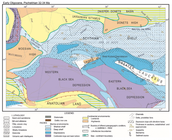
Fig. 3. Paleogeographic map of the Euxine basin in the Early Oligocene (Popov et al., 2004, modified). Figure courtesy Sergej V. Popov.
Early Maikopian shallow-water sandy facies with shells of mollusks, alluvial fans, and paleo-channels are described from the western part of the Kerch Peninsula, where they framed the Crimean ledge. Sedimentary rocks, which can be considered as shelf sediments (spongolites of middle Maikopian) have been preserved in the Anapa region at the periclinal of the Caucasus. At the beginning of the Miocene, the western part of the West Kuban Depression was filled. In the eastern part, the depth difference remained high and reached up to 1000 m (Antipov in Popov et al., 2010).
2. Middle Miocene (Karaganian) basin
After the late Burdigalian paleogeographic and paleoenvironmental reorganization, the prevalence of marine environments with fluctuating salinities changed during the later Chokrakian – Karaganian time period into a semi-marine regime (10-14%o) with impoverished euryhaline endemic faunas.
In the relatively deep-water environments of the southeastern part of Kerch and in most parts of the Taman, dark clays with impoverished foraminiferal associations were formed (fig. 4). Clays with rhythmic interlayers of limestones, marls, dolomites, and sandstones with abundant mollusks Davidaschvilia gentilis (Eichw.) were accumulated nearshore, suggesting transport of clastics from the uplifts of the Western Caucasus and the Crimea (Arkhangel’skii et al., 1930; Zhizhchenko in Neogen SSSR, 1940). The cyclicity of sediments reflects periodical changes of wet and dry episodes compatible with Milankovitch cycles. The oxygen isotope data from calcite (shells and carbonate rocks) of the Karaganian suggests that the clays were deposited during warm, wet periods, while the accumulation of carbonates usually occurred in the cooler and dryer periods (Rostovtseva, 2012).
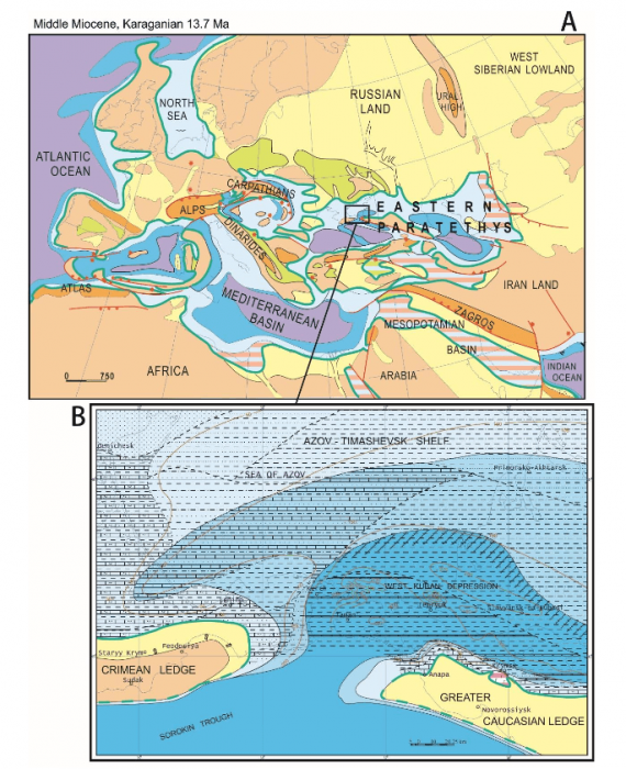
Fig. 4. Paleogeographic map of Western Eurasia at the Middle Miocene (Popov et al., 2004, modified) (A) and more detail one for the Crimean – Caucasian junction and Azov area. Figure courtesy Sergej V. Popov.
In shallow water settings of the Anapa region, facies of shelly limestones with Davidaschvilia gentilis reached a thickness of 14 m and included oolitic interlayers and limestones with lime worms Serpula.
3. Late Miocene (Maeotian) basin
The sea level drop at the Sarmatian s.l.-Maeotian transition was estimated to be about 300 m (Tugolesov et al. 1985; Popov et al, 2010). Unconformities between the freshened upper Sarmatian and semi-marine early Maeotian deposits are very common, suggesting drying up of large areas. The maximal transgression occurred during the middle of the early Maeotian. The early Maeotian Basin was inhabited by mainly endemic species and subspecies of euryhaline Mediterranean genera, which evolved in gulfs and lagoons of the late Tortonian – early Messinian sea.
During the early Maeotian, the subaqueous breccia (up to several tens of meters) were formed on the slopes of actively growing anticlines. The bryozoan-algal buildups (up to 10 m) began to grow in marginal parts at the tops of underwater uplifts (fig. 5). Further transgression led to a decrease in the growth rate of the bryozoan-algal buildups and to the formation of stromatolite crusts at their tops. In the western Azov area, calcareous clays with interlayers of limestone and shelly material up to 30 m thick were predominantly accumulated. Shell-detrital sediments prevailed toward the north and accumulated in high energy environments. On the Azov-Timashevsk shelf, clays with interbeds of sand with shell material and oolitic limestones up to 5–6 m thick were deposited. In the Anapa area, shelly limestones and thick bryozoan-algal buildups (up to 50 m) were formed under the wave action.
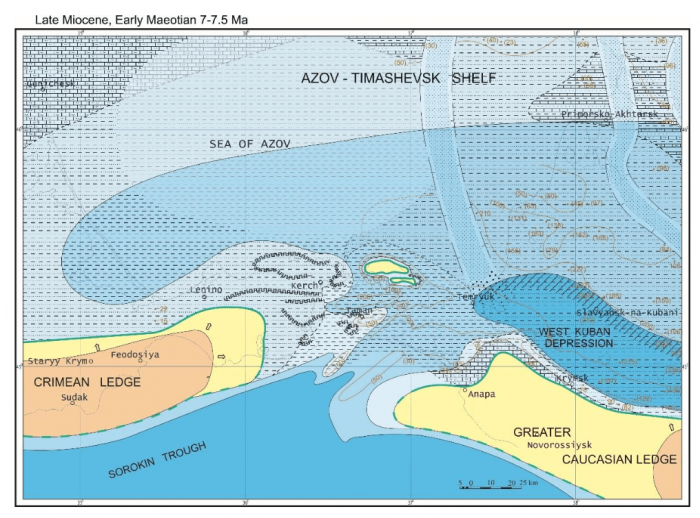
Fig. 5. Paleogeographic map of the Crimean – Caucasian junction and Azov area during the Middle Miocene. Figure courtesy Sergej V. Popov.
At the beginning of the Pontian, almost the entire studied area was a shallow shelf. The basin was inhabited by a rich endemic brackish-water fauna of Pannonian and Aegean origin. Relatively deep-water settings existed only in the axial part of the West Kuban trough.


